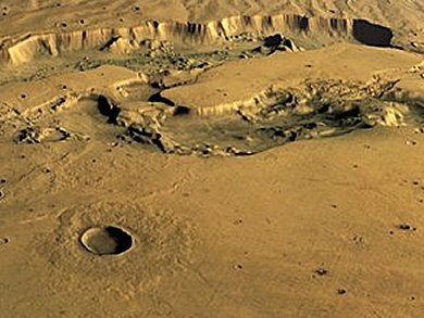
In June 2002, the European Space Agency (ESA) spacecraft Mars Express was launched to investigate our neighbouring planet for one Mars year. This is equivalent to about two earth years. The spacecraft has been orbiting Mars for ten years now and has orbited the planet almost 12,000 times. Data taken with a special camera with nine light-sensitive detectors that sweep the surface in sequence from nine different observation angles, is processed into three-dimensional images by planetary researchers of the German Aerospace Center (Deutsches Zentrum für Luft- und Raumfahrt; DLR), Berlin, Germany.
Of the 145 million km2 of the surface, 97 million have been covered at very high resolution, where one pixel corresponds to less than 20 m on the surface. Almost the entire surface of Mars has been imaged at a resolution of better than 100 m. A 3D image of Mars has been created, enabling the researchers to acquire new and surprising information about the climate and development of the Red Planet
Three to four billion years ago water must have flown over the surface of Mars. Images show geological processes in which water was involved. It is likely that there were periods of flowing and standing water during the history of the planet. This means that different climatic conditions must have been predominant in the planet’s early history. This is also visible in images showing structures near the equator that have been caused by glaciation. This is not compatible with todays climate on the dry and dusty Red Planet.
The spacecraft is now due to continue orbiting Mars until the end of 2014.
Image ©: ESA/DLR/FU Berlin (G. Neukum).
- German Aerospace Center (Deutsches Zentrum fuer Luft- und Raumfahrt; DLR), Berlin, Germany
- View pictures of Mars
http://www.mex10.dlr.de/index-en.html


